|
|
|||||||||||||||||
| Point ID: 6428 | Downloads | Plots | Site Data | Code: 7098 |
|
|
|||||||||||||||||
| Download | |
|---|---|
| Site Descriptor Information | Site Time Series Data |
| Link to all available data | |
| View: | Time Series | All |
| Units: | m3/s |
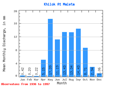
| Statistic | Jan | Feb | Mar | Apr | May | Jun | Jul | Aug | Sep | Oct | Nov | Dec | Annual |
|---|---|---|---|---|---|---|---|---|---|---|---|---|---|
| Mean | 0.42 | 0.20 | 0.22 | 5.15 | 17.38 | 11.19 | 13.43 | 13.34 | 14.44 | 8.71 | 2.94 | 1.06 | 89.85 |
| Standard Deviation | 0.36 | 0.17 | 0.19 | 3.56 | 8.70 | 7.14 | 9.22 | 8.13 | 10.94 | 5.27 | 3.98 | 0.73 | 36.65 |
| Min | 0.00 | 0.00 | 0.00 | 0.25 | 4.39 | 0.84 | 2.37 | 1.95 | 1.73 | 1.51 | 0.36 | 0.04 | 22.23 |
| Max | 1.56 | 0.69 | 0.81 | 16.64 | 40.43 | 37.52 | 43.97 | 39.80 | 52.34 | 25.95 | 31.87 | 3.26 | 163.52 |
| Coefficient of Variation | 0.85 | 0.84 | 0.85 | 0.69 | 0.50 | 0.64 | 0.69 | 0.61 | 0.76 | 0.60 | 1.36 | 0.69 | 0.41 |
 Return to R-Arctic Net Home Page