|
|
|||||||||||||||||
| Point ID: 6427 | Downloads | Plots | Site Data | Code: 7096 |
|
|
|||||||||||||||||
| Download | |
|---|---|
| Site Descriptor Information | Site Time Series Data |
| Link to all available data | |
| View: | Time Series | All |
| Units: | mm |
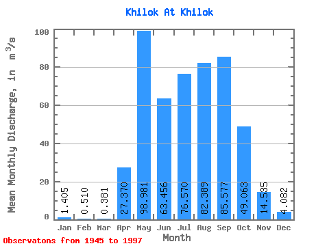
| Statistic | Jan | Feb | Mar | Apr | May | Jun | Jul | Aug | Sep | Oct | Nov | Dec | Annual |
|---|---|---|---|---|---|---|---|---|---|---|---|---|---|
| Mean | 1.41 | 0.51 | 0.38 | 27.37 | 98.98 | 63.46 | 76.57 | 82.39 | 85.58 | 49.06 | 14.54 | 4.08 | 42.03 |
| Standard Deviation | 1.78 | 1.11 | 0.89 | 19.38 | 51.79 | 46.41 | 51.28 | 60.77 | 62.06 | 30.38 | 9.12 | 3.18 | 17.80 |
| Min | 0.00 | 0.00 | 0.00 | 0.00 | 0.00 | 1.72 | 9.12 | 11.10 | 17.10 | 9.55 | 1.55 | 0.07 | 13.69 |
| Max | 6.99 | 4.90 | 3.61 | 70.10 | 223.00 | 217.00 | 251.00 | 351.00 | 255.00 | 140.00 | 42.70 | 14.70 | 79.21 |
| Coefficient of Variation | 1.27 | 2.17 | 2.32 | 0.71 | 0.52 | 0.73 | 0.67 | 0.74 | 0.72 | 0.62 | 0.63 | 0.78 | 0.42 |
 Return to R-Arctic Net Home Page