|
|
|||||||||||||||||
| Point ID: 6427 | Downloads | Plots | Site Data | Code: 7096 |
|
|
|||||||||||||||||
| Download | |
|---|---|
| Site Descriptor Information | Site Time Series Data |
| Link to all available data | |
| View: | Time Series | All |
| Units: | m3/s |
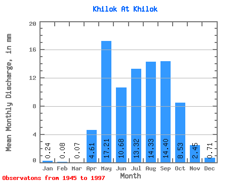
| Statistic | Jan | Feb | Mar | Apr | May | Jun | Jul | Aug | Sep | Oct | Nov | Dec | Annual |
|---|---|---|---|---|---|---|---|---|---|---|---|---|---|
| Mean | 0.24 | 0.08 | 0.07 | 4.61 | 17.21 | 10.68 | 13.31 | 14.33 | 14.40 | 8.53 | 2.45 | 0.71 | 86.13 |
| Standard Deviation | 0.31 | 0.17 | 0.15 | 3.26 | 9.01 | 7.81 | 8.92 | 10.57 | 10.45 | 5.28 | 1.54 | 0.55 | 36.47 |
| Min | 0.00 | 0.00 | 0.00 | 0.00 | 0.00 | 0.29 | 1.59 | 1.93 | 2.88 | 1.66 | 0.26 | 0.01 | 28.06 |
| Max | 1.22 | 0.78 | 0.63 | 11.80 | 38.78 | 36.52 | 43.65 | 61.04 | 42.92 | 24.34 | 7.19 | 2.56 | 162.34 |
| Coefficient of Variation | 1.27 | 2.17 | 2.32 | 0.71 | 0.52 | 0.73 | 0.67 | 0.74 | 0.72 | 0.62 | 0.63 | 0.78 | 0.42 |
 Return to R-Arctic Net Home Page