|
|
|||||||||||||||||
| Point ID: 6412 | Downloads | Plots | Site Data | Other Close Sites | Code: 7051 |
|
|
|||||||||||||||||
| Download | |
|---|---|
| Site Descriptor Information | Site Time Series Data |
| Link to all available data | |
| View: | Time Series | All |
| Units: | mm |
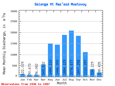
| Statistic | Jan | Feb | Mar | Apr | May | Jun | Jul | Aug | Sep | Oct | Nov | Dec | Annual |
|---|---|---|---|---|---|---|---|---|---|---|---|---|---|
| Mean | 122.03 | 90.67 | 96.08 | 549.53 | 1484.21 | 1446.00 | 1884.13 | 2076.68 | 1847.26 | 1110.10 | 334.13 | 188.44 | 935.77 |
| Standard Deviation | 42.86 | 36.42 | 41.48 | 211.89 | 482.99 | 539.66 | 668.45 | 792.26 | 692.35 | 299.87 | 89.83 | 50.33 | 212.37 |
| Min | 47.60 | 34.70 | 38.20 | 128.00 | 741.00 | 608.00 | 756.00 | 875.00 | 718.00 | 543.00 | 180.00 | 113.00 | 514.99 |
| Max | 229.00 | 225.00 | 279.00 | 1030.00 | 3150.00 | 3830.00 | 3620.00 | 4360.00 | 3530.00 | 1920.00 | 599.00 | 315.00 | 1472.09 |
| Coefficient of Variation | 0.35 | 0.40 | 0.43 | 0.39 | 0.33 | 0.37 | 0.35 | 0.38 | 0.38 | 0.27 | 0.27 | 0.27 | 0.23 |
| Other Close Sites | ||||||
|---|---|---|---|---|---|---|
| PointID | Latitude | Longitude | Drainage Area | Source | Name | |
| 6439 | "Uda At Ulan-Ude" | 51.83 | 1261875 | SHI | 5.10 | |
 Return to R-Arctic Net Home Page