|
|
|||||||||||||||||
| Point ID: 641 | Downloads | Plots | Site Data | Code: 07BA001 |
|
|
|||||||||||||||||
| Download | |
|---|---|
| Site Descriptor Information | Site Time Series Data |
| Link to all available data | |
| View: | Time Series | All |
| Units: | mm |
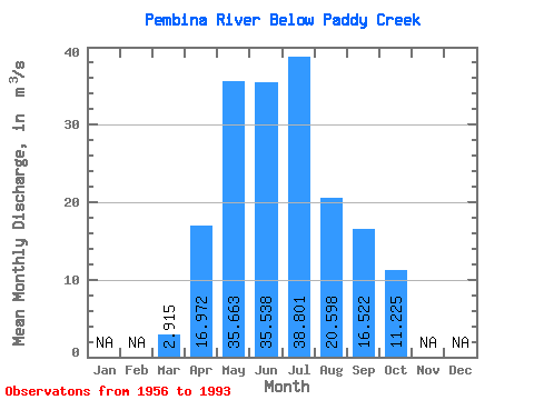
| Statistic | Jan | Feb | Mar | Apr | May | Jun | Jul | Aug | Sep | Oct | Nov | Dec | Annual |
|---|---|---|---|---|---|---|---|---|---|---|---|---|---|
| Mean | 2.92 | 16.97 | 35.66 | 35.54 | 38.80 | 20.60 | 16.52 | 11.22 | |||||
| Standard Deviation | 1.98 | 10.10 | 18.99 | 30.27 | 38.29 | 20.32 | 13.19 | 7.70 | |||||
| Min | 1.33 | 3.75 | 6.58 | 8.95 | 5.98 | 3.49 | 3.23 | 3.44 | |||||
| Max | 13.50 | 48.20 | 88.40 | 149.00 | 188.00 | 100.00 | 53.80 | 35.50 | |||||
| Coefficient of Variation | 0.68 | 0.59 | 0.53 | 0.85 | 0.99 | 0.99 | 0.80 | 0.69 |
 Return to R-Arctic Net Home Page