|
|
|||||||||||||||||
| Point ID: 641 | Downloads | Plots | Site Data | Code: 07BA001 |
|
|
|||||||||||||||||
| Download | |
|---|---|
| Site Descriptor Information | Site Time Series Data |
| Link to all available data | |
| View: | Time Series | All |
| Units: | m3/s |
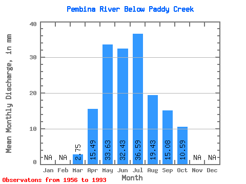
| Statistic | Jan | Feb | Mar | Apr | May | Jun | Jul | Aug | Sep | Oct | Nov | Dec | Annual |
|---|---|---|---|---|---|---|---|---|---|---|---|---|---|
| Mean | 2.69 | 15.17 | 32.93 | 31.76 | 35.83 | 19.02 | 14.77 | 10.37 | |||||
| Standard Deviation | 1.82 | 9.03 | 17.54 | 27.05 | 35.36 | 18.76 | 11.79 | 7.11 | |||||
| Min | 1.23 | 3.35 | 6.08 | 8.00 | 5.52 | 3.22 | 2.89 | 3.18 | |||||
| Max | 12.47 | 43.08 | 81.63 | 133.18 | 173.61 | 92.34 | 48.09 | 32.78 | |||||
| Coefficient of Variation | 0.68 | 0.59 | 0.53 | 0.85 | 0.99 | 0.99 | 0.80 | 0.69 |
 Return to R-Arctic Net Home Page