|
|
|||||||||||||||||
| Point ID: 637 | Downloads | Plots | Site Data | Code: 07AG008 |
|
|
|||||||||||||||||
| Download | |
|---|---|
| Site Descriptor Information | Site Time Series Data |
| Link to all available data | |
| View: | Time Series | All |
| Units: | mm |
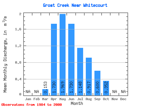
| Statistic | Jan | Feb | Mar | Apr | May | Jun | Jul | Aug | Sep | Oct | Nov | Dec | Annual |
|---|---|---|---|---|---|---|---|---|---|---|---|---|---|
| Mean | 0.15 | 1.73 | 1.97 | 1.73 | 1.15 | 0.92 | 0.60 | 0.35 | |||||
| Standard Deviation | 0.17 | 1.31 | 1.11 | 1.51 | 0.80 | 1.68 | 0.65 | 0.23 | |||||
| Min | 0.03 | 0.42 | 0.56 | 0.35 | 0.22 | 0.14 | 0.14 | 0.19 | |||||
| Max | 0.76 | 4.73 | 3.53 | 5.30 | 2.74 | 6.99 | 2.37 | 1.08 | |||||
| Coefficient of Variation | 1.12 | 0.76 | 0.56 | 0.87 | 0.70 | 1.83 | 1.08 | 0.65 |
 Return to R-Arctic Net Home Page