|
|
|||||||||||||||||
| Point ID: 637 | Downloads | Plots | Site Data | Code: 07AG008 |
|
|
|||||||||||||||||
| Download | |
|---|---|
| Site Descriptor Information | Site Time Series Data |
| Link to all available data | |
| View: | Time Series | All |
| Units: | m3/s |
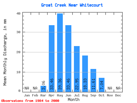
| Statistic | Jan | Feb | Mar | Apr | May | Jun | Jul | Aug | Sep | Oct | Nov | Dec | Annual |
|---|---|---|---|---|---|---|---|---|---|---|---|---|---|
| Mean | 3.06 | 33.47 | 39.36 | 33.47 | 22.94 | 18.32 | 11.60 | 7.04 | |||||
| Standard Deviation | 3.43 | 25.27 | 22.18 | 29.16 | 15.99 | 33.56 | 12.53 | 4.54 | |||||
| Min | 0.66 | 8.05 | 11.13 | 6.81 | 4.46 | 2.80 | 2.63 | 3.82 | |||||
| Max | 15.17 | 91.49 | 70.55 | 102.52 | 54.76 | 139.70 | 45.84 | 21.58 | |||||
| Coefficient of Variation | 1.12 | 0.76 | 0.56 | 0.87 | 0.70 | 1.83 | 1.08 | 0.65 |
 Return to R-Arctic Net Home Page