|
|
|||||||||||||||||
| Point ID: 6355 | Downloads | Plots | Site Data | Code: 3882 |
|
|
|||||||||||||||||
| Download | |
|---|---|
| Site Descriptor Information | Site Time Series Data |
| Link to all available data | |
| View: | Time Series | All |
| Units: | mm |
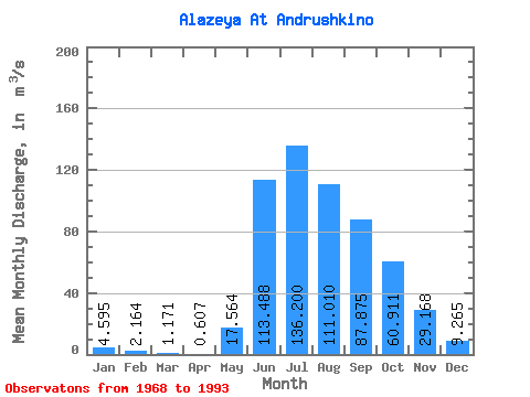
| Statistic | Jan | Feb | Mar | Apr | May | Jun | Jul | Aug | Sep | Oct | Nov | Dec | Annual |
|---|---|---|---|---|---|---|---|---|---|---|---|---|---|
| Mean | 4.59 | 2.16 | 1.17 | 0.61 | 17.56 | 113.49 | 136.20 | 111.01 | 87.88 | 60.91 | 29.17 | 9.27 | 45.90 |
| Standard Deviation | 3.76 | 1.90 | 1.11 | 0.72 | 50.74 | 41.96 | 49.86 | 59.96 | 60.99 | 48.56 | 32.34 | 10.18 | 19.02 |
| Min | 0.14 | 0.00 | 0.00 | 0.00 | 0.05 | 36.60 | 17.10 | 20.80 | 10.10 | 7.03 | 1.42 | 0.38 | 11.11 |
| Max | 12.10 | 5.44 | 3.48 | 2.42 | 213.00 | 185.00 | 212.00 | 209.00 | 201.00 | 165.00 | 108.00 | 43.50 | 79.77 |
| Coefficient of Variation | 0.82 | 0.88 | 0.94 | 1.19 | 2.89 | 0.37 | 0.37 | 0.54 | 0.69 | 0.80 | 1.11 | 1.10 | 0.41 |
 Return to R-Arctic Net Home Page