|
|
|||||||||||||||||
| Point ID: 6355 | Downloads | Plots | Site Data | Code: 3882 |
|
|
|||||||||||||||||
| Download | |
|---|---|
| Site Descriptor Information | Site Time Series Data |
| Link to all available data | |
| View: | Time Series | All |
| Units: | m3/s |
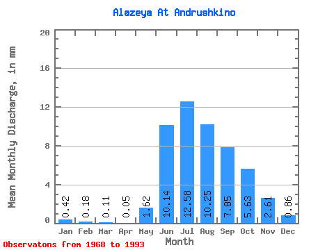
| Statistic | Jan | Feb | Mar | Apr | May | Jun | Jul | Aug | Sep | Oct | Nov | Dec | Annual |
|---|---|---|---|---|---|---|---|---|---|---|---|---|---|
| Mean | 0.42 | 0.18 | 0.11 | 0.05 | 1.62 | 10.14 | 12.58 | 10.25 | 7.85 | 5.62 | 2.61 | 0.86 | 49.95 |
| Standard Deviation | 0.35 | 0.16 | 0.10 | 0.07 | 4.69 | 3.75 | 4.60 | 5.54 | 5.45 | 4.49 | 2.89 | 0.94 | 20.70 |
| Min | 0.01 | 0.00 | 0.00 | 0.00 | 0.01 | 3.27 | 1.58 | 1.92 | 0.90 | 0.65 | 0.13 | 0.04 | 12.09 |
| Max | 1.12 | 0.46 | 0.32 | 0.22 | 19.67 | 16.54 | 19.58 | 19.30 | 17.96 | 15.24 | 9.65 | 4.02 | 86.81 |
| Coefficient of Variation | 0.82 | 0.88 | 0.94 | 1.19 | 2.89 | 0.37 | 0.37 | 0.54 | 0.69 | 0.80 | 1.11 | 1.10 | 0.41 |
 Return to R-Arctic Net Home Page