|
|
|||||||||||||||||
| Point ID: 6343 | Downloads | Plots | Site Data | Code: 3824 |
|
|
|||||||||||||||||
| Download | |
|---|---|
| Site Descriptor Information | Site Time Series Data |
| Link to all available data | |
| View: | Time Series | All |
| Units: | mm |
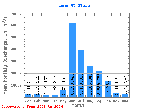
| Statistic | Jan | Feb | Mar | Apr | May | Jun | Jul | Aug | Sep | Oct | Nov | Dec | Annual |
|---|---|---|---|---|---|---|---|---|---|---|---|---|---|
| Mean | 3141.32 | 2669.21 | 2119.16 | 1758.84 | 5909.16 | 61833.42 | 39478.37 | 26166.84 | 21889.79 | 13196.47 | 3341.89 | 3073.95 | 15381.53 |
| Standard Deviation | 514.84 | 526.56 | 452.22 | 376.37 | 5955.56 | 10569.40 | 7689.11 | 6639.05 | 6390.32 | 3751.42 | 929.52 | 688.46 | 2199.06 |
| Min | 2280.00 | 2024.00 | 1436.00 | 1130.00 | 927.00 | 37212.00 | 25082.00 | 12783.00 | 13490.00 | 4863.00 | 1527.00 | 2104.00 | 10646.00 |
| Max | 4121.00 | 4009.00 | 2958.00 | 2463.00 | 22750.00 | 85880.00 | 54019.00 | 41430.00 | 32120.00 | 18583.00 | 5000.00 | 4629.00 | 20118.33 |
| Coefficient of Variation | 0.16 | 0.20 | 0.21 | 0.21 | 1.01 | 0.17 | 0.20 | 0.25 | 0.29 | 0.28 | 0.28 | 0.22 | 0.14 |
 Return to R-Arctic Net Home Page