|
|
|||||||||||||||||
| Point ID: 6343 | Downloads | Plots | Site Data | Code: 3824 |
|
|
|||||||||||||||||
| Download | |
|---|---|
| Site Descriptor Information | Site Time Series Data |
| Link to all available data | |
| View: | Time Series | All |
| Units: | m3/s |
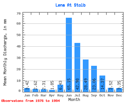
| Statistic | Jan | Feb | Mar | Apr | May | Jun | Jul | Aug | Sep | Oct | Nov | Dec | Annual |
|---|---|---|---|---|---|---|---|---|---|---|---|---|---|
| Mean | 3.42 | 2.65 | 2.31 | 1.85 | 6.43 | 65.15 | 42.98 | 28.49 | 23.06 | 14.37 | 3.52 | 3.35 | 197.33 |
| Standard Deviation | 0.56 | 0.52 | 0.49 | 0.40 | 6.48 | 11.14 | 8.37 | 7.23 | 6.73 | 4.08 | 0.98 | 0.75 | 28.21 |
| Min | 2.48 | 2.01 | 1.56 | 1.19 | 1.01 | 39.21 | 27.30 | 13.92 | 14.21 | 5.29 | 1.61 | 2.29 | 136.58 |
| Max | 4.49 | 3.98 | 3.22 | 2.59 | 24.77 | 90.49 | 58.81 | 45.10 | 33.84 | 20.23 | 5.27 | 5.04 | 258.10 |
| Coefficient of Variation | 0.16 | 0.20 | 0.21 | 0.21 | 1.01 | 0.17 | 0.20 | 0.25 | 0.29 | 0.28 | 0.28 | 0.22 | 0.14 |
 Return to R-Arctic Net Home Page