|
|
|||||||||||||||||
| Point ID: 6312 | Downloads | Plots | Site Data | Code: 3540 |
|
|
|||||||||||||||||
| Download | |
|---|---|
| Site Descriptor Information | Site Time Series Data |
| Link to all available data | |
| View: | Time Series | All |
| Units: | mm |
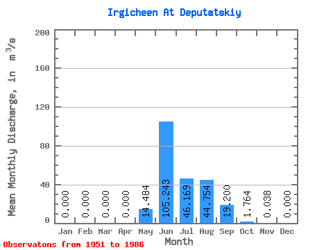
| Statistic | Jan | Feb | Mar | Apr | May | Jun | Jul | Aug | Sep | Oct | Nov | Dec | Annual |
|---|---|---|---|---|---|---|---|---|---|---|---|---|---|
| Mean | 0.00 | 0.00 | 0.00 | 0.00 | 14.48 | 105.24 | 46.17 | 44.75 | 19.20 | 1.76 | 0.04 | 0.00 | 19.06 |
| Standard Deviation | 0.00 | 0.00 | 0.00 | 0.00 | 19.77 | 36.66 | 23.81 | 34.00 | 17.05 | 2.17 | 0.06 | 0.00 | 5.85 |
| Min | 0.00 | 0.00 | 0.00 | 0.00 | 0.00 | 29.80 | 6.02 | 6.27 | 1.95 | 0.08 | 0.00 | 0.00 | 11.99 |
| Max | 0.00 | 0.00 | 0.00 | 0.00 | 74.80 | 176.00 | 92.10 | 148.00 | 73.60 | 9.84 | 0.22 | 0.00 | 33.97 |
| Coefficient of Variation | 1.36 | 0.35 | 0.52 | 0.76 | 0.89 | 1.23 | 1.54 | 4.12 | 0.31 |
 Return to R-Arctic Net Home Page