|
|
|||||||||||||||||
| Point ID: 6312 | Downloads | Plots | Site Data | Code: 3540 |
|
|
|||||||||||||||||
| Download | |
|---|---|
| Site Descriptor Information | Site Time Series Data |
| Link to all available data | |
| View: | Time Series | All |
| Units: | m3/s |
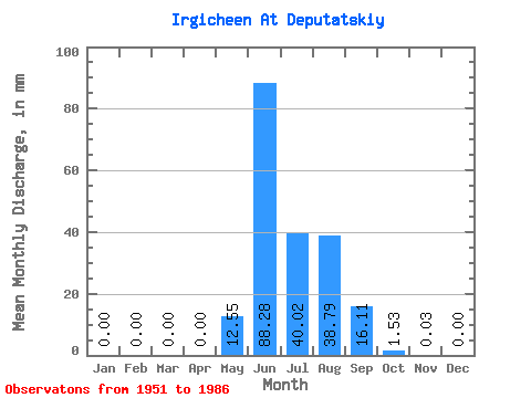
| Statistic | Jan | Feb | Mar | Apr | May | Jun | Jul | Aug | Sep | Oct | Nov | Dec | Annual |
|---|---|---|---|---|---|---|---|---|---|---|---|---|---|
| Mean | 0.00 | 0.00 | 0.00 | 0.00 | 12.55 | 88.28 | 40.01 | 38.79 | 16.11 | 1.53 | 0.03 | 0.00 | 194.67 |
| Standard Deviation | 0.00 | 0.00 | 0.00 | 0.00 | 17.13 | 30.75 | 20.64 | 29.47 | 14.30 | 1.89 | 0.05 | 0.00 | 59.76 |
| Min | 0.00 | 0.00 | 0.00 | 0.00 | 0.00 | 25.00 | 5.22 | 5.43 | 1.64 | 0.07 | 0.00 | 0.00 | 122.44 |
| Max | 0.00 | 0.00 | 0.00 | 0.00 | 64.83 | 147.63 | 79.82 | 128.27 | 61.74 | 8.53 | 0.18 | 0.00 | 346.96 |
| Coefficient of Variation | 1.36 | 0.35 | 0.52 | 0.76 | 0.89 | 1.23 | 1.54 | 4.12 | 0.31 |
 Return to R-Arctic Net Home Page