|
|
|||||||||||||||||
| Point ID: 6303 | Downloads | Plots | Site Data | Code: 3488 |
|
|
|||||||||||||||||
| Download | |
|---|---|
| Site Descriptor Information | Site Time Series Data |
| Link to all available data | |
| View: | Time Series | All |
| Units: | mm |
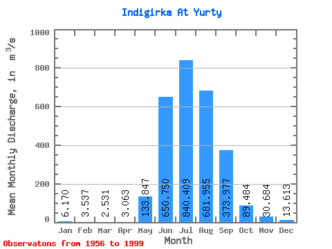
| Statistic | Jan | Feb | Mar | Apr | May | Jun | Jul | Aug | Sep | Oct | Nov | Dec | Annual |
|---|---|---|---|---|---|---|---|---|---|---|---|---|---|
| Mean | 6.17 | 3.54 | 2.53 | 3.06 | 133.85 | 650.75 | 840.41 | 681.96 | 373.98 | 89.48 | 30.68 | 13.61 | 235.84 |
| Standard Deviation | 2.73 | 1.73 | 1.29 | 1.98 | 120.36 | 270.31 | 250.38 | 237.87 | 161.71 | 23.41 | 7.29 | 4.57 | 51.78 |
| Min | 1.41 | 0.92 | 0.00 | 0.29 | 8.37 | 203.00 | 493.00 | 330.00 | 130.00 | 48.80 | 18.10 | 4.02 | 132.11 |
| Max | 11.40 | 8.10 | 5.98 | 10.10 | 618.00 | 1210.00 | 1590.00 | 1260.00 | 856.00 | 138.00 | 46.10 | 29.40 | 352.76 |
| Coefficient of Variation | 0.44 | 0.49 | 0.51 | 0.65 | 0.90 | 0.41 | 0.30 | 0.35 | 0.43 | 0.26 | 0.24 | 0.34 | 0.22 |
 Return to R-Arctic Net Home Page