|
|
|||||||||||||||||
| Point ID: 6303 | Downloads | Plots | Site Data | Code: 3488 |
|
|
|||||||||||||||||
| Download | |
|---|---|
| Site Descriptor Information | Site Time Series Data |
| Link to all available data | |
| View: | Time Series | All |
| Units: | m3/s |
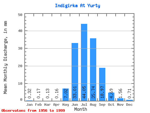
| Statistic | Jan | Feb | Mar | Apr | May | Jun | Jul | Aug | Sep | Oct | Nov | Dec | Annual |
|---|---|---|---|---|---|---|---|---|---|---|---|---|---|
| Mean | 0.32 | 0.17 | 0.13 | 0.15 | 7.01 | 33.01 | 44.04 | 35.74 | 18.97 | 4.69 | 1.56 | 0.71 | 145.66 |
| Standard Deviation | 0.14 | 0.08 | 0.07 | 0.10 | 6.31 | 13.71 | 13.12 | 12.47 | 8.20 | 1.23 | 0.37 | 0.24 | 31.98 |
| Min | 0.07 | 0.04 | 0.00 | 0.01 | 0.44 | 10.30 | 25.84 | 17.29 | 6.59 | 2.56 | 0.92 | 0.21 | 81.59 |
| Max | 0.60 | 0.39 | 0.31 | 0.51 | 32.39 | 61.38 | 83.33 | 66.03 | 43.42 | 7.23 | 2.34 | 1.54 | 217.87 |
| Coefficient of Variation | 0.44 | 0.49 | 0.51 | 0.65 | 0.90 | 0.41 | 0.30 | 0.35 | 0.43 | 0.26 | 0.24 | 0.34 | 0.22 |
 Return to R-Arctic Net Home Page