|
|
|||||||||||||||||
| Point ID: 6301 | Downloads | Plots | Site Data | Code: 3479 |
|
|
|||||||||||||||||
| Download | |
|---|---|
| Site Descriptor Information | Site Time Series Data |
| Link to all available data | |
| View: | Time Series | All |
| Units: | mm |
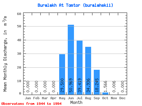
| Statistic | Jan | Feb | Mar | Apr | May | Jun | Jul | Aug | Sep | Oct | Nov | Dec | Annual |
|---|---|---|---|---|---|---|---|---|---|---|---|---|---|
| Mean | 0.00 | 0.00 | 0.00 | 0.00 | 29.50 | 50.97 | 39.42 | 34.94 | 18.25 | 1.57 | 0.01 | 0.00 | 14.69 |
| Standard Deviation | 0.00 | 0.00 | 0.00 | 0.00 | 29.86 | 39.40 | 33.20 | 28.30 | 16.23 | 2.62 | 0.02 | 0.00 | 8.15 |
| Min | 0.00 | 0.00 | 0.00 | 0.00 | 0.04 | 10.20 | 4.50 | 4.06 | 1.19 | -1.05 | 0.00 | 0.00 | 3.76 |
| Max | 0.00 | 0.00 | 0.00 | 0.00 | 119.00 | 149.00 | 130.00 | 121.00 | 62.90 | 13.10 | 0.11 | 0.00 | 31.75 |
| Coefficient of Variation | 1.01 | 0.77 | 0.84 | 0.81 | 0.89 | 1.68 | 3.37 | 0.56 |
 Return to R-Arctic Net Home Page