|
|
|||||||||||||||||
| Point ID: 6301 | Downloads | Plots | Site Data | Code: 3479 |
|
|
|||||||||||||||||
| Download | |
|---|---|
| Site Descriptor Information | Site Time Series Data |
| Link to all available data | |
| View: | Time Series | All |
| Units: | m3/s |
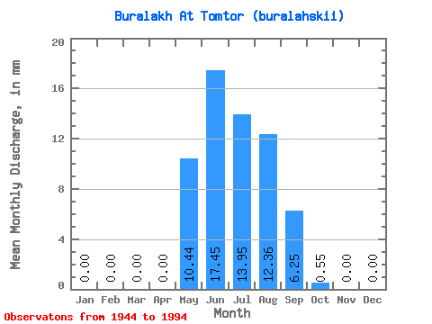
| Statistic | Jan | Feb | Mar | Apr | May | Jun | Jul | Aug | Sep | Oct | Nov | Dec | Annual |
|---|---|---|---|---|---|---|---|---|---|---|---|---|---|
| Mean | 0.00 | 0.00 | 0.00 | 0.00 | 10.44 | 17.45 | 13.95 | 12.36 | 6.25 | 0.55 | 0.00 | 0.00 | 61.23 |
| Standard Deviation | 0.00 | 0.00 | 0.00 | 0.00 | 10.56 | 13.49 | 11.75 | 10.01 | 5.56 | 0.93 | 0.01 | 0.00 | 33.96 |
| Min | 0.00 | 0.00 | 0.00 | 0.00 | 0.02 | 3.49 | 1.59 | 1.44 | 0.41 | -0.37 | 0.00 | 0.00 | 15.69 |
| Max | 0.00 | 0.00 | 0.00 | 0.00 | 42.10 | 51.02 | 45.99 | 42.81 | 21.54 | 4.63 | 0.04 | 0.00 | 132.39 |
| Coefficient of Variation | 1.01 | 0.77 | 0.84 | 0.81 | 0.89 | 1.68 | 3.37 | 0.56 |
 Return to R-Arctic Net Home Page