|
|
|||||||||||||||||
| Point ID: 6300 | Downloads | Plots | Site Data | Code: 3474 |
|
|
|||||||||||||||||
| Download | |
|---|---|
| Site Descriptor Information | Site Time Series Data |
| Link to all available data | |
| View: | Time Series | All |
| Units: | mm |
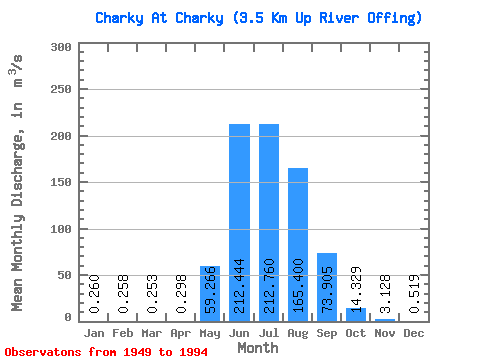
| Statistic | Jan | Feb | Mar | Apr | May | Jun | Jul | Aug | Sep | Oct | Nov | Dec | Annual |
|---|---|---|---|---|---|---|---|---|---|---|---|---|---|
| Mean | 0.26 | 0.26 | 0.25 | 0.30 | 59.27 | 212.44 | 212.76 | 165.40 | 73.91 | 14.33 | 3.13 | 0.52 | 63.48 |
| Standard Deviation | 1.74 | 1.73 | 1.70 | 2.00 | 116.34 | 95.61 | 90.98 | 76.33 | 36.17 | 8.02 | 2.18 | 1.93 | 15.59 |
| Min | 0.00 | 0.00 | 0.00 | 0.00 | 1.78 | 43.20 | 64.20 | 19.50 | 19.00 | 5.84 | 0.11 | 0.00 | 27.48 |
| Max | 11.70 | 11.60 | 11.40 | 13.40 | 795.00 | 480.00 | 500.00 | 403.00 | 196.00 | 54.90 | 12.60 | 12.80 | 100.69 |
| Coefficient of Variation | 6.71 | 6.71 | 6.71 | 6.71 | 1.96 | 0.45 | 0.43 | 0.46 | 0.49 | 0.56 | 0.70 | 3.72 | 0.25 |
 Return to R-Arctic Net Home Page