|
|
|||||||||||||||||
| Point ID: 6300 | Downloads | Plots | Site Data | Code: 3474 |
|
|
|||||||||||||||||
| Download | |
|---|---|
| Site Descriptor Information | Site Time Series Data |
| Link to all available data | |
| View: | Time Series | All |
| Units: | m3/s |
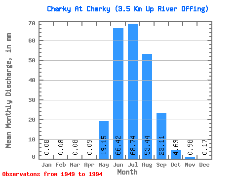
| Statistic | Jan | Feb | Mar | Apr | May | Jun | Jul | Aug | Sep | Oct | Nov | Dec | Annual |
|---|---|---|---|---|---|---|---|---|---|---|---|---|---|
| Mean | 0.08 | 0.08 | 0.08 | 0.09 | 19.14 | 66.42 | 68.73 | 53.43 | 23.11 | 4.63 | 0.98 | 0.17 | 241.66 |
| Standard Deviation | 0.56 | 0.51 | 0.55 | 0.62 | 37.58 | 29.89 | 29.39 | 24.66 | 11.31 | 2.59 | 0.68 | 0.62 | 59.33 |
| Min | 0.00 | 0.00 | 0.00 | 0.00 | 0.57 | 13.51 | 20.74 | 6.30 | 5.94 | 1.89 | 0.03 | 0.00 | 104.64 |
| Max | 3.78 | 3.41 | 3.68 | 4.19 | 256.82 | 150.08 | 161.52 | 130.19 | 61.28 | 17.73 | 3.94 | 4.13 | 383.35 |
| Coefficient of Variation | 6.71 | 6.71 | 6.71 | 6.71 | 1.96 | 0.45 | 0.43 | 0.46 | 0.49 | 0.56 | 0.70 | 3.72 | 0.25 |
 Return to R-Arctic Net Home Page