|
|
|||||||||||||||||
| Point ID: 6290 | Downloads | Plots | Site Data | Code: 3404 |
|
|
|||||||||||||||||
| Download | |
|---|---|
| Site Descriptor Information | Site Time Series Data |
| Link to all available data | |
| View: | Time Series | All |
| Units: | mm |
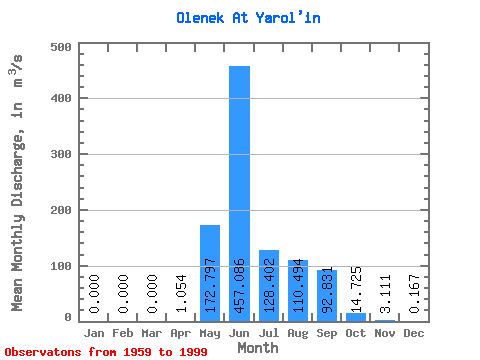
| Statistic | Jan | Feb | Mar | Apr | May | Jun | Jul | Aug | Sep | Oct | Nov | Dec | Annual |
|---|---|---|---|---|---|---|---|---|---|---|---|---|---|
| Mean | 0.00 | 0.00 | 0.00 | 1.05 | 172.80 | 457.09 | 128.40 | 110.49 | 92.83 | 14.72 | 3.11 | 0.17 | 82.00 |
| Standard Deviation | 0.00 | 0.00 | 0.00 | 6.24 | 165.13 | 231.35 | 101.19 | 103.75 | 63.42 | 12.58 | 4.72 | 0.43 | 19.42 |
| Min | 0.00 | 0.00 | 0.00 | 0.00 | 0.00 | 137.00 | 3.26 | 2.63 | 1.74 | 0.29 | 0.00 | 0.00 | 47.97 |
| Max | 0.00 | 0.00 | 0.00 | 36.90 | 639.00 | 1070.00 | 387.00 | 376.00 | 261.00 | 43.70 | 21.50 | 2.47 | 124.29 |
| Coefficient of Variation | 5.92 | 0.96 | 0.51 | 0.79 | 0.94 | 0.68 | 0.85 | 1.52 | 2.59 | 0.24 |
 Return to R-Arctic Net Home Page