|
|
|||||||||||||||||
| Point ID: 6290 | Downloads | Plots | Site Data | Code: 3404 |
|
|
|||||||||||||||||
| Download | |
|---|---|
| Site Descriptor Information | Site Time Series Data |
| Link to all available data | |
| View: | Time Series | All |
| Units: | m3/s |
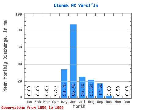
| Statistic | Jan | Feb | Mar | Apr | May | Jun | Jul | Aug | Sep | Oct | Nov | Dec | Annual |
|---|---|---|---|---|---|---|---|---|---|---|---|---|---|
| Mean | 0.00 | 0.00 | 0.00 | 0.20 | 33.78 | 86.48 | 25.10 | 21.60 | 17.56 | 2.88 | 0.59 | 0.03 | 188.89 |
| Standard Deviation | 0.00 | 0.00 | 0.00 | 1.18 | 32.28 | 43.77 | 19.78 | 20.28 | 12.00 | 2.46 | 0.89 | 0.08 | 44.73 |
| Min | 0.00 | 0.00 | 0.00 | 0.00 | 0.00 | 25.92 | 0.64 | 0.51 | 0.33 | 0.06 | 0.00 | 0.00 | 110.51 |
| Max | 0.00 | 0.00 | 0.00 | 6.98 | 124.91 | 202.44 | 75.65 | 73.50 | 49.38 | 8.54 | 4.07 | 0.48 | 286.33 |
| Coefficient of Variation | 5.92 | 0.96 | 0.51 | 0.79 | 0.94 | 0.68 | 0.85 | 1.52 | 2.59 | 0.24 |
 Return to R-Arctic Net Home Page