|
|
|||||||||||||||||
| Point ID: 629 | Downloads | Plots | Site Data | Code: 07AF910 |
|
|
|||||||||||||||||
| Download | |
|---|---|
| Site Descriptor Information | Site Time Series Data |
| Link to all available data | |
| View: | Time Series | All |
| Units: | mm |
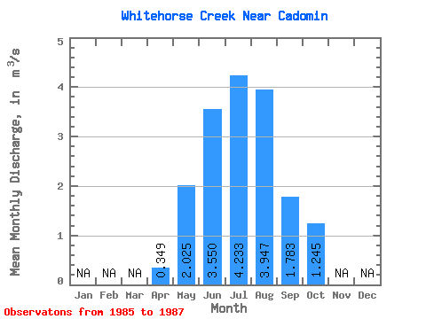
| Statistic | Jan | Feb | Mar | Apr | May | Jun | Jul | Aug | Sep | Oct | Nov | Dec | Annual |
|---|---|---|---|---|---|---|---|---|---|---|---|---|---|
| Mean | 0.35 | 2.02 | 3.55 | 4.23 | 3.95 | 1.78 | 1.25 | ||||||
| Standard Deviation | 0.39 | 1.62 | 3.21 | 2.49 | 0.97 | 0.72 | |||||||
| Min | 0.35 | 1.75 | 1.76 | 2.30 | 1.68 | 1.11 | 0.72 | ||||||
| Max | 0.35 | 2.30 | 4.93 | 7.94 | 6.61 | 2.89 | 2.06 | ||||||
| Coefficient of Variation | 0.19 | 0.46 | 0.76 | 0.63 | 0.54 | 0.57 |
 Return to R-Arctic Net Home Page