|
|
|||||||||||||||||
| Point ID: 629 | Downloads | Plots | Site Data | Code: 07AF910 |
|
|
|||||||||||||||||
| Download | |
|---|---|
| Site Descriptor Information | Site Time Series Data |
| Link to all available data | |
| View: | Time Series | All |
| Units: | m3/s |
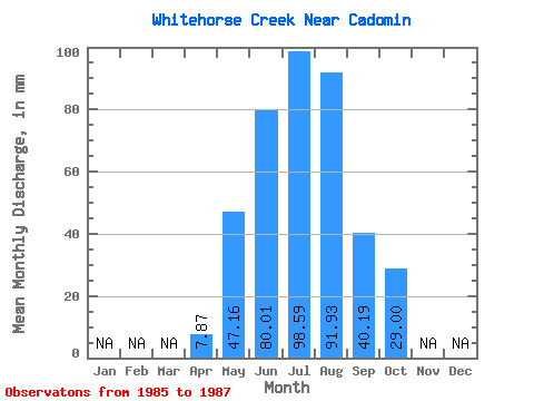
| Statistic | Jan | Feb | Mar | Apr | May | Jun | Jul | Aug | Sep | Oct | Nov | Dec | Annual |
|---|---|---|---|---|---|---|---|---|---|---|---|---|---|
| Mean | 7.87 | 47.16 | 80.01 | 98.58 | 91.91 | 40.20 | 29.00 | ||||||
| Standard Deviation | 9.06 | 36.61 | 74.78 | 57.96 | 21.77 | 16.67 | |||||||
| Min | 7.87 | 40.75 | 39.67 | 53.56 | 39.12 | 25.02 | 16.70 | ||||||
| Max | 7.87 | 53.56 | 111.12 | 184.90 | 153.93 | 65.14 | 47.97 | ||||||
| Coefficient of Variation | 0.19 | 0.46 | 0.76 | 0.63 | 0.54 | 0.57 |
 Return to R-Arctic Net Home Page