|
|
|||||||||||||||||
| Point ID: 6276 | Downloads | Plots | Site Data | Code: 3360 |
|
|
|||||||||||||||||
| Download | |
|---|---|
| Site Descriptor Information | Site Time Series Data |
| Link to all available data | |
| View: | Time Series | All |
| Units: | mm |
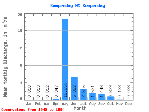
| Statistic | Jan | Feb | Mar | Apr | May | Jun | Jul | Aug | Sep | Oct | Nov | Dec | Annual |
|---|---|---|---|---|---|---|---|---|---|---|---|---|---|
| Mean | 0.02 | 0.01 | 0.01 | 0.35 | 18.65 | 5.36 | 2.52 | 1.53 | 1.45 | 0.84 | 0.13 | 0.04 | 2.58 |
| Standard Deviation | 0.03 | 0.02 | 0.02 | 0.91 | 10.19 | 3.54 | 2.43 | 2.06 | 1.44 | 0.62 | 0.13 | 0.05 | 1.17 |
| Min | 0.00 | 0.00 | 0.00 | 0.00 | 0.11 | 1.40 | 0.52 | 0.28 | 0.26 | 0.11 | 0.00 | 0.00 | 0.63 |
| Max | 0.10 | 0.07 | 0.07 | 5.40 | 46.70 | 16.70 | 12.60 | 11.10 | 7.69 | 2.30 | 0.47 | 0.20 | 5.53 |
| Coefficient of Variation | 1.47 | 1.47 | 1.54 | 2.62 | 0.55 | 0.66 | 0.96 | 1.34 | 0.99 | 0.74 | 0.95 | 1.39 | 0.46 |
 Return to R-Arctic Net Home Page