|
|
|||||||||||||||||
| Point ID: 6276 | Downloads | Plots | Site Data | Code: 3360 |
|
|
|||||||||||||||||
| Download | |
|---|---|
| Site Descriptor Information | Site Time Series Data |
| Link to all available data | |
| View: | Time Series | All |
| Units: | m3/s |
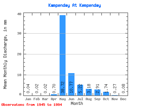
| Statistic | Jan | Feb | Mar | Apr | May | Jun | Jul | Aug | Sep | Oct | Nov | Dec | Annual |
|---|---|---|---|---|---|---|---|---|---|---|---|---|---|
| Mean | 0.04 | 0.02 | 0.03 | 0.70 | 38.72 | 10.78 | 5.22 | 3.18 | 2.91 | 1.74 | 0.27 | 0.08 | 63.01 |
| Standard Deviation | 0.06 | 0.04 | 0.04 | 1.82 | 21.15 | 7.12 | 5.04 | 4.27 | 2.89 | 1.29 | 0.26 | 0.11 | 28.73 |
| Min | 0.00 | 0.00 | 0.00 | 0.00 | 0.23 | 2.81 | 1.08 | 0.58 | 0.52 | 0.23 | 0.00 | 0.00 | 15.45 |
| Max | 0.21 | 0.13 | 0.14 | 10.85 | 96.95 | 33.55 | 26.16 | 23.04 | 15.45 | 4.78 | 0.94 | 0.41 | 135.35 |
| Coefficient of Variation | 1.47 | 1.47 | 1.54 | 2.62 | 0.55 | 0.66 | 0.96 | 1.34 | 0.99 | 0.74 | 0.95 | 1.39 | 0.46 |
 Return to R-Arctic Net Home Page