|
|
|||||||||||||||||
| Point ID: 6260 | Downloads | Plots | Site Data | Code: 3306 |
|
|
|||||||||||||||||
| Download | |
|---|---|
| Site Descriptor Information | Site Time Series Data |
| Link to all available data | |
| View: | Time Series | All |
| Units: | mm |
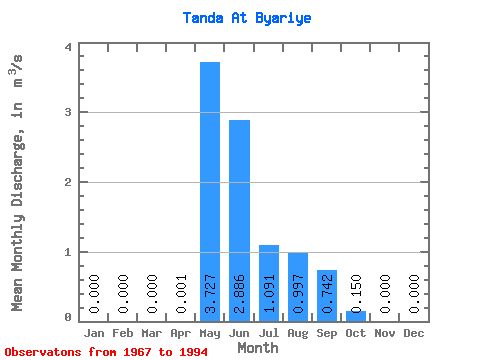
| Statistic | Jan | Feb | Mar | Apr | May | Jun | Jul | Aug | Sep | Oct | Nov | Dec | Annual |
|---|---|---|---|---|---|---|---|---|---|---|---|---|---|
| Mean | 0.00 | 0.00 | 0.00 | 0.00 | 3.73 | 2.89 | 1.09 | 1.00 | 0.74 | 0.15 | 0.00 | 0.00 | 0.64 |
| Standard Deviation | 0.00 | 0.00 | 0.00 | 0.00 | 4.80 | 3.80 | 1.02 | 2.44 | 2.29 | 0.45 | 0.00 | 0.00 | 0.75 |
| Min | 0.00 | 0.00 | 0.00 | 0.00 | 0.00 | 0.00 | 0.00 | 0.00 | 0.00 | 0.00 | 0.00 | 0.00 | 0.01 |
| Max | 0.00 | 0.00 | 0.00 | 0.01 | 14.30 | 11.70 | 3.58 | 10.20 | 9.53 | 1.69 | 0.00 | 0.00 | 2.39 |
| Coefficient of Variation | 3.46 | 1.29 | 1.32 | 0.94 | 2.45 | 3.08 | 2.99 | 1.18 |
 Return to R-Arctic Net Home Page