|
|
|||||||||||||||||
| Point ID: 6260 | Downloads | Plots | Site Data | Code: 3306 |
|
|
|||||||||||||||||
| Download | |
|---|---|
| Site Descriptor Information | Site Time Series Data |
| Link to all available data | |
| View: | Time Series | All |
| Units: | m3/s |
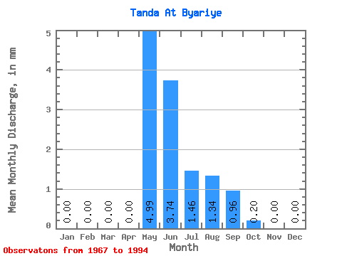
| Statistic | Jan | Feb | Mar | Apr | May | Jun | Jul | Aug | Sep | Oct | Nov | Dec | Annual |
|---|---|---|---|---|---|---|---|---|---|---|---|---|---|
| Mean | 0.00 | 0.00 | 0.00 | 0.00 | 4.99 | 3.74 | 1.46 | 1.33 | 0.96 | 0.20 | 0.00 | 0.00 | 10.03 |
| Standard Deviation | 0.00 | 0.00 | 0.00 | 0.00 | 6.43 | 4.92 | 1.37 | 3.27 | 2.96 | 0.60 | 0.00 | 0.00 | 11.85 |
| Min | 0.00 | 0.00 | 0.00 | 0.00 | 0.00 | 0.00 | 0.00 | 0.00 | 0.00 | 0.00 | 0.00 | 0.00 | 0.07 |
| Max | 0.00 | 0.00 | 0.00 | 0.01 | 19.15 | 15.16 | 4.79 | 13.66 | 12.35 | 2.26 | 0.00 | 0.00 | 37.77 |
| Coefficient of Variation | 3.46 | 1.29 | 1.32 | 0.94 | 2.45 | 3.08 | 2.99 | 1.18 |
 Return to R-Arctic Net Home Page