|
|
|||||||||||||||||
| Point ID: 6256 | Downloads | Plots | Site Data | Code: 3292 |
|
|
|||||||||||||||||
| Download | |
|---|---|
| Site Descriptor Information | Site Time Series Data |
| Link to all available data | |
| View: | Time Series | All |
| Units: | mm |
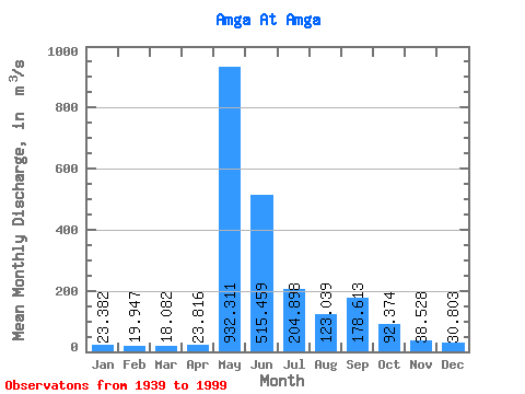
| Statistic | Jan | Feb | Mar | Apr | May | Jun | Jul | Aug | Sep | Oct | Nov | Dec | Annual |
|---|---|---|---|---|---|---|---|---|---|---|---|---|---|
| Mean | 23.38 | 19.95 | 18.08 | 23.82 | 932.31 | 515.46 | 204.90 | 123.04 | 178.61 | 92.37 | 38.53 | 30.80 | 183.98 |
| Standard Deviation | 7.87 | 6.61 | 5.95 | 21.60 | 353.61 | 236.56 | 171.25 | 95.65 | 149.62 | 70.23 | 19.34 | 12.47 | 56.02 |
| Min | 10.60 | 7.67 | 8.38 | 10.80 | 264.00 | 147.00 | 42.70 | 29.30 | 28.60 | 0.00 | 0.00 | 0.00 | 57.12 |
| Max | 45.60 | 38.50 | 35.60 | 168.00 | 1790.00 | 1060.00 | 1060.00 | 465.00 | 606.00 | 394.00 | 107.00 | 63.40 | 342.61 |
| Coefficient of Variation | 0.34 | 0.33 | 0.33 | 0.91 | 0.38 | 0.46 | 0.84 | 0.78 | 0.84 | 0.76 | 0.50 | 0.41 | 0.30 |
 Return to R-Arctic Net Home Page