|
|
|||||||||||||||||
| Point ID: 6256 | Downloads | Plots | Site Data | Code: 3292 |
|
|
|||||||||||||||||
| Download | |
|---|---|
| Site Descriptor Information | Site Time Series Data |
| Link to all available data | |
| View: | Time Series | All |
| Units: | m3/s |
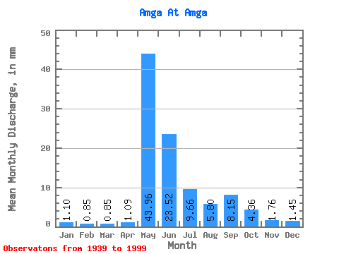
| Statistic | Jan | Feb | Mar | Apr | May | Jun | Jul | Aug | Sep | Oct | Nov | Dec | Annual |
|---|---|---|---|---|---|---|---|---|---|---|---|---|---|
| Mean | 1.10 | 0.86 | 0.85 | 1.09 | 43.96 | 23.52 | 9.66 | 5.80 | 8.15 | 4.36 | 1.76 | 1.45 | 102.23 |
| Standard Deviation | 0.37 | 0.28 | 0.28 | 0.99 | 16.67 | 10.79 | 8.07 | 4.51 | 6.83 | 3.31 | 0.88 | 0.59 | 31.13 |
| Min | 0.50 | 0.33 | 0.40 | 0.49 | 12.45 | 6.71 | 2.01 | 1.38 | 1.30 | 0.00 | 0.00 | 0.00 | 31.74 |
| Max | 2.15 | 1.65 | 1.68 | 7.67 | 84.39 | 48.37 | 49.98 | 21.92 | 27.65 | 18.58 | 4.88 | 2.99 | 190.37 |
| Coefficient of Variation | 0.34 | 0.33 | 0.33 | 0.91 | 0.38 | 0.46 | 0.84 | 0.78 | 0.84 | 0.76 | 0.50 | 0.41 | 0.30 |
 Return to R-Arctic Net Home Page