|
|
|||||||||||||||||
| Point ID: 6254 | Downloads | Plots | Site Data | Code: 3288 |
|
|
|||||||||||||||||
| Download | |
|---|---|
| Site Descriptor Information | Site Time Series Data |
| Link to all available data | |
| View: | Time Series | All |
| Units: | mm |
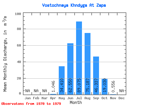
| Statistic | Jan | Feb | Mar | Apr | May | Jun | Jul | Aug | Sep | Oct | Nov | Dec | Annual |
|---|---|---|---|---|---|---|---|---|---|---|---|---|---|
| Mean | 1.05 | 34.41 | 62.55 | 89.08 | 75.19 | 46.34 | 19.03 | 0.56 | |||||
| Standard Deviation | 1.80 | 40.87 | 20.01 | 31.98 | 32.80 | 26.33 | 14.52 | 0.85 | |||||
| Min | 0.01 | 2.61 | 35.50 | 42.90 | 44.60 | 20.30 | 3.49 | 0.04 | |||||
| Max | 4.63 | 135.00 | 101.00 | 131.00 | 136.00 | 105.00 | 42.80 | 1.83 | |||||
| Coefficient of Variation | 1.72 | 1.19 | 0.32 | 0.36 | 0.44 | 0.57 | 0.76 | 1.53 |
 Return to R-Arctic Net Home Page