|
|
|||||||||||||||||
| Point ID: 6254 | Downloads | Plots | Site Data | Code: 3288 |
|
|
|||||||||||||||||
| Download | |
|---|---|
| Site Descriptor Information | Site Time Series Data |
| Link to all available data | |
| View: | Time Series | All |
| Units: | m3/s |
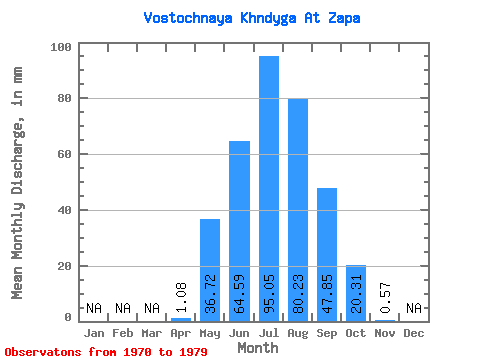
| Statistic | Jan | Feb | Mar | Apr | May | Jun | Jul | Aug | Sep | Oct | Nov | Dec | Annual |
|---|---|---|---|---|---|---|---|---|---|---|---|---|---|
| Mean | 1.08 | 36.71 | 64.59 | 95.04 | 80.22 | 47.85 | 20.30 | 0.57 | |||||
| Standard Deviation | 1.86 | 43.60 | 20.67 | 34.12 | 35.00 | 27.19 | 15.49 | 0.88 | |||||
| Min | 0.01 | 2.79 | 36.66 | 45.77 | 47.59 | 20.96 | 3.72 | 0.05 | |||||
| Max | 4.78 | 144.04 | 104.30 | 139.77 | 145.10 | 108.43 | 45.66 | 1.89 | |||||
| Coefficient of Variation | 1.72 | 1.19 | 0.32 | 0.36 | 0.44 | 0.57 | 0.76 | 1.53 |
 Return to R-Arctic Net Home Page