|
|
|||||||||||||||||
| Point ID: 625 | Downloads | Plots | Site Data | Code: 07AF016 |
|
|
|||||||||||||||||
| Download | |
|---|---|
| Site Descriptor Information | Site Time Series Data |
| Link to all available data | |
| View: | Time Series | All |
| Units: | mm |
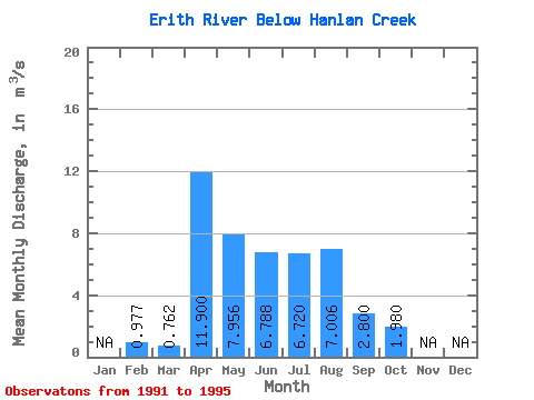
| Statistic | Jan | Feb | Mar | Apr | May | Jun | Jul | Aug | Sep | Oct | Nov | Dec | Annual |
|---|---|---|---|---|---|---|---|---|---|---|---|---|---|
| Mean | 0.98 | 0.76 | 11.90 | 7.96 | 6.79 | 6.72 | 7.01 | 2.80 | 1.98 | ||||
| Standard Deviation | 5.39 | 3.46 | 3.69 | 7.33 | 1.43 | 0.65 | |||||||
| Min | 0.98 | 0.76 | 11.90 | 3.90 | 2.95 | 2.08 | 0.85 | 1.21 | 1.15 | ||||
| Max | 0.98 | 0.76 | 11.90 | 17.40 | 11.60 | 11.30 | 19.70 | 5.10 | 2.86 | ||||
| Coefficient of Variation | 0.68 | 0.51 | 0.55 | 1.05 | 0.51 | 0.33 |
 Return to R-Arctic Net Home Page