|
|
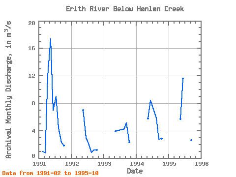
| Point ID: 625 | Downloads | Plots | Site Data | Code: 07AF016 |
|
| Download | |
|---|---|
| Site Descriptor Information | Site Time Series Data |
| Link to all available data | |
|
|
|
| View: | Statistics | All |
| Units: | mm |
| Year | Jan | Feb | Mar | Apr | May | Jun | Jul | Aug | Sep | Oct | Nov | Dec | Annual | 1991 | 0.98 | 0.76 | 11.90 | 17.40 | 6.91 | 8.98 | 4.43 | 2.27 | 1.83 | 1992 | 7.02 | 2.95 | 2.08 | 0.85 | 1.21 | 1.15 | 1993 | 3.90 | 4.08 | 4.12 | 4.22 | 5.10 | 2.36 | 1994 | 5.76 | 8.40 | 7.12 | 5.83 | 2.78 | 2.86 | 1995 | 5.70 | 11.60 | 11.30 | 19.70 | 2.64 | 1.70 |
|---|
 Return to R-Arctic Net Home Page