|
|
|||||||||||||||||
| Point ID: 6239 | Downloads | Plots | Site Data | Code: 3237 |
|
|
|||||||||||||||||
| Download | |
|---|---|
| Site Descriptor Information | Site Time Series Data |
| Link to all available data | |
| View: | Time Series | All |
| Units: | mm |
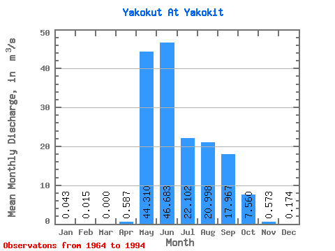
| Statistic | Jan | Feb | Mar | Apr | May | Jun | Jul | Aug | Sep | Oct | Nov | Dec | Annual |
|---|---|---|---|---|---|---|---|---|---|---|---|---|---|
| Mean | 0.04 | 0.01 | 0.00 | 0.59 | 44.31 | 46.68 | 22.10 | 21.00 | 17.97 | 7.56 | 0.57 | 0.17 | 13.42 |
| Standard Deviation | 0.14 | 0.08 | 0.00 | 1.53 | 14.36 | 22.05 | 14.30 | 14.38 | 11.42 | 5.31 | 0.77 | 0.41 | 4.22 |
| Min | 0.00 | 0.00 | 0.00 | 0.00 | 21.00 | 18.60 | 3.14 | 2.39 | 3.66 | 0.96 | 0.00 | 0.00 | 5.17 |
| Max | 0.72 | 0.44 | 0.00 | 7.45 | 81.90 | 93.30 | 66.30 | 53.40 | 43.80 | 24.50 | 2.92 | 1.60 | 21.03 |
| Coefficient of Variation | 3.31 | 5.48 | 2.61 | 0.32 | 0.47 | 0.65 | 0.69 | 0.64 | 0.70 | 1.34 | 2.36 | 0.32 |
 Return to R-Arctic Net Home Page