|
|
|||||||||||||||||
| Point ID: 6239 | Downloads | Plots | Site Data | Code: 3237 |
|
|
|||||||||||||||||
| Download | |
|---|---|
| Site Descriptor Information | Site Time Series Data |
| Link to all available data | |
| View: | Time Series | All |
| Units: | m3/s |
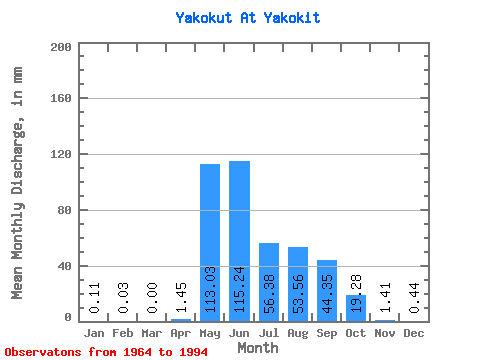
| Statistic | Jan | Feb | Mar | Apr | May | Jun | Jul | Aug | Sep | Oct | Nov | Dec | Annual |
|---|---|---|---|---|---|---|---|---|---|---|---|---|---|
| Mean | 0.11 | 0.03 | 0.00 | 1.45 | 113.01 | 115.24 | 56.37 | 53.55 | 44.35 | 19.28 | 1.41 | 0.44 | 403.30 |
| Standard Deviation | 0.36 | 0.19 | 0.00 | 3.78 | 36.63 | 54.43 | 36.48 | 36.67 | 28.20 | 13.53 | 1.90 | 1.05 | 126.88 |
| Min | 0.00 | 0.00 | 0.00 | 0.00 | 53.56 | 45.91 | 8.01 | 6.10 | 9.04 | 2.45 | 0.00 | 0.00 | 155.34 |
| Max | 1.84 | 1.02 | 0.00 | 18.39 | 208.88 | 230.32 | 169.10 | 136.19 | 108.12 | 62.49 | 7.21 | 4.08 | 632.10 |
| Coefficient of Variation | 3.31 | 5.48 | 2.61 | 0.32 | 0.47 | 0.65 | 0.69 | 0.64 | 0.70 | 1.34 | 2.36 | 0.32 |
 Return to R-Arctic Net Home Page