|
|
|||||||||||||||||
| Point ID: 6236 | Downloads | Plots | Site Data | Code: 3229 |
|
|
|||||||||||||||||
| Download | |
|---|---|
| Site Descriptor Information | Site Time Series Data |
| Link to all available data | |
| View: | Time Series | All |
| Units: | mm |
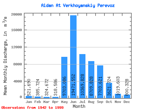
| Statistic | Jan | Feb | Mar | Apr | May | Jun | Jul | Aug | Sep | Oct | Nov | Dec | Annual |
|---|---|---|---|---|---|---|---|---|---|---|---|---|---|
| Mean | 521.69 | 385.72 | 324.67 | 318.59 | 9703.09 | 19471.55 | 10369.83 | 8709.83 | 7703.62 | 3621.72 | 1019.60 | 800.33 | 5245.85 |
| Standard Deviation | 213.01 | 177.36 | 156.17 | 148.21 | 4400.44 | 5049.38 | 3300.53 | 2964.42 | 2786.62 | 1487.47 | 380.13 | 272.56 | 813.92 |
| Min | 143.00 | 147.00 | 153.00 | 148.00 | 459.00 | 8950.00 | 5020.00 | 2940.00 | 3430.00 | 1660.00 | 516.00 | 434.00 | 3770.00 |
| Max | 1410.00 | 930.00 | 780.00 | 754.00 | 22200.00 | 34700.00 | 18400.00 | 14700.00 | 17000.00 | 10300.00 | 2400.00 | 1900.00 | 7452.67 |
| Coefficient of Variation | 0.41 | 0.46 | 0.48 | 0.47 | 0.45 | 0.26 | 0.32 | 0.34 | 0.36 | 0.41 | 0.37 | 0.34 | 0.15 |
 Return to R-Arctic Net Home Page