|
|
|||||||||||||||||
| Point ID: 6236 | Downloads | Plots | Site Data | Code: 3229 |
|
|
|||||||||||||||||
| Download | |
|---|---|
| Site Descriptor Information | Site Time Series Data |
| Link to all available data | |
| View: | Time Series | All |
| Units: | m3/s |
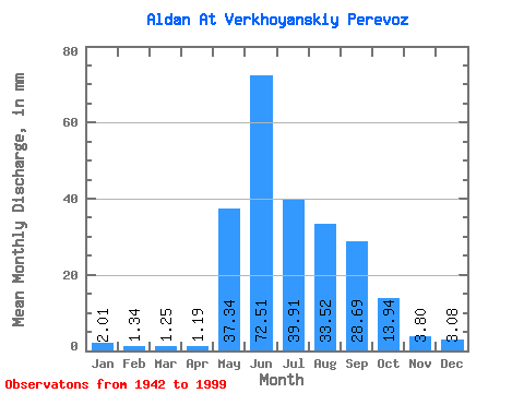
| Statistic | Jan | Feb | Mar | Apr | May | Jun | Jul | Aug | Sep | Oct | Nov | Dec | Annual |
|---|---|---|---|---|---|---|---|---|---|---|---|---|---|
| Mean | 2.01 | 1.35 | 1.25 | 1.19 | 37.34 | 72.52 | 39.90 | 33.51 | 28.69 | 13.94 | 3.80 | 3.08 | 237.87 |
| Standard Deviation | 0.82 | 0.62 | 0.60 | 0.55 | 16.93 | 18.80 | 12.70 | 11.41 | 10.38 | 5.72 | 1.42 | 1.05 | 36.91 |
| Min | 0.55 | 0.52 | 0.59 | 0.55 | 1.77 | 33.33 | 19.32 | 11.31 | 12.77 | 6.39 | 1.92 | 1.67 | 170.95 |
| Max | 5.42 | 3.26 | 3.00 | 2.81 | 85.42 | 129.23 | 70.80 | 56.56 | 63.31 | 39.63 | 8.94 | 7.31 | 337.94 |
| Coefficient of Variation | 0.41 | 0.46 | 0.48 | 0.47 | 0.45 | 0.26 | 0.32 | 0.34 | 0.36 | 0.41 | 0.37 | 0.34 | 0.15 |
 Return to R-Arctic Net Home Page