|
|
|||||||||||||||||
| Point ID: 6202 | Downloads | Plots | Site Data | Code: 3148 |
|
|
|||||||||||||||||
| Download | |
|---|---|
| Site Descriptor Information | Site Time Series Data |
| Link to all available data | |
| View: | Time Series | All |
| Units: | mm |
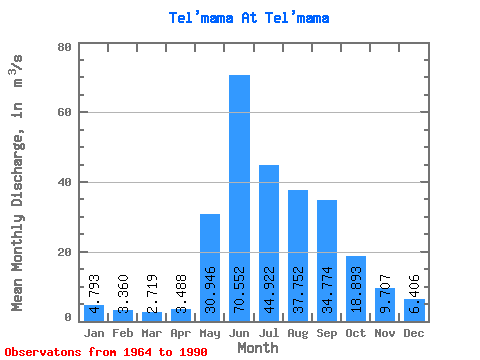
| Statistic | Jan | Feb | Mar | Apr | May | Jun | Jul | Aug | Sep | Oct | Nov | Dec | Annual |
|---|---|---|---|---|---|---|---|---|---|---|---|---|---|
| Mean | 4.79 | 3.36 | 2.72 | 3.49 | 30.95 | 70.55 | 44.92 | 37.75 | 34.77 | 18.89 | 9.71 | 6.41 | 22.32 |
| Standard Deviation | 1.38 | 1.05 | 0.90 | 1.87 | 7.65 | 13.48 | 15.30 | 12.47 | 11.66 | 4.35 | 2.90 | 2.15 | 3.52 |
| Min | 2.46 | 1.60 | 1.13 | 0.98 | 13.90 | 45.20 | 23.60 | 20.60 | 15.80 | 11.10 | 5.74 | 3.38 | 16.00 |
| Max | 6.94 | 6.31 | 4.83 | 9.96 | 45.50 | 103.00 | 81.70 | 65.60 | 63.90 | 30.80 | 15.80 | 10.70 | 32.72 |
| Coefficient of Variation | 0.29 | 0.31 | 0.33 | 0.54 | 0.25 | 0.19 | 0.34 | 0.33 | 0.34 | 0.23 | 0.30 | 0.34 | 0.16 |
 Return to R-Arctic Net Home Page