|
|
|||||||||||||||||
| Point ID: 6202 | Downloads | Plots | Site Data | Code: 3148 |
|
|
|||||||||||||||||
| Download | |
|---|---|
| Site Descriptor Information | Site Time Series Data |
| Link to all available data | |
| View: | Time Series | All |
| Units: | m3/s |
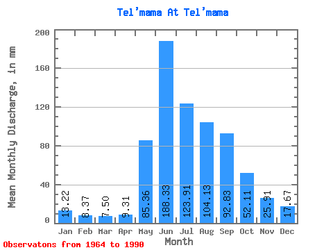
| Statistic | Jan | Feb | Mar | Apr | May | Jun | Jul | Aug | Sep | Oct | Nov | Dec | Annual |
|---|---|---|---|---|---|---|---|---|---|---|---|---|---|
| Mean | 13.22 | 8.44 | 7.50 | 9.31 | 85.35 | 188.33 | 123.89 | 104.12 | 92.83 | 52.10 | 25.91 | 17.67 | 725.44 |
| Standard Deviation | 3.79 | 2.63 | 2.47 | 4.99 | 21.09 | 35.99 | 42.20 | 34.38 | 31.13 | 11.99 | 7.75 | 5.93 | 114.45 |
| Min | 6.79 | 4.02 | 3.12 | 2.62 | 38.34 | 120.66 | 65.09 | 56.81 | 42.18 | 30.61 | 15.32 | 9.32 | 519.96 |
| Max | 19.14 | 15.86 | 13.32 | 26.59 | 125.49 | 274.95 | 225.33 | 180.92 | 170.57 | 84.95 | 42.18 | 29.51 | 1063.62 |
| Coefficient of Variation | 0.29 | 0.31 | 0.33 | 0.54 | 0.25 | 0.19 | 0.34 | 0.33 | 0.34 | 0.23 | 0.30 | 0.34 | 0.16 |
 Return to R-Arctic Net Home Page