|
|
|||||||||||||||||
| Point ID: 6183 | Downloads | Plots | Site Data | Code: 3119 |
|
|
|||||||||||||||||
| Download | |
|---|---|
| Site Descriptor Information | Site Time Series Data |
| Link to all available data | |
| View: | Time Series | All |
| Units: | mm |
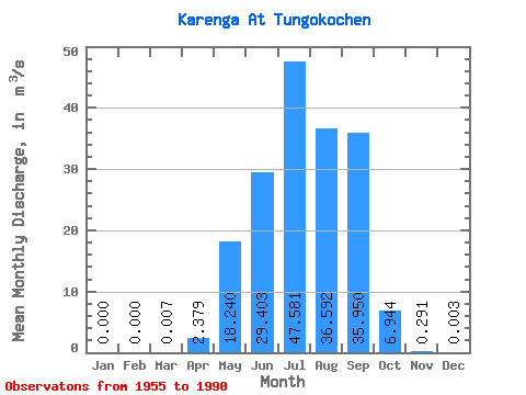
| Statistic | Jan | Feb | Mar | Apr | May | Jun | Jul | Aug | Sep | Oct | Nov | Dec | Annual |
|---|---|---|---|---|---|---|---|---|---|---|---|---|---|
| Mean | 0.00 | 0.00 | 0.01 | 2.38 | 18.24 | 29.40 | 47.58 | 36.59 | 35.95 | 6.94 | 0.29 | 0.00 | 14.78 |
| Standard Deviation | 0.00 | 0.00 | 0.04 | 3.93 | 17.48 | 30.02 | 43.85 | 35.36 | 27.22 | 4.84 | 0.28 | 0.02 | 8.48 |
| Min | 0.00 | 0.00 | 0.00 | 0.00 | 0.57 | 0.29 | 1.55 | 1.74 | 0.78 | 0.35 | 0.01 | 0.00 | 1.71 |
| Max | 0.00 | 0.00 | 0.24 | 15.70 | 61.20 | 105.00 | 177.00 | 142.00 | 89.70 | 22.60 | 1.19 | 0.10 | 33.50 |
| Coefficient of Variation | 6.00 | 1.65 | 0.96 | 1.02 | 0.92 | 0.97 | 0.76 | 0.70 | 0.95 | 5.10 | 0.57 |
 Return to R-Arctic Net Home Page