|
|
|||||||||||||||||
| Point ID: 6183 | Downloads | Plots | Site Data | Code: 3119 |
|
|
|||||||||||||||||
| Download | |
|---|---|
| Site Descriptor Information | Site Time Series Data |
| Link to all available data | |
| View: | Time Series | All |
| Units: | m3/s |
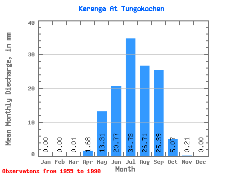
| Statistic | Jan | Feb | Mar | Apr | May | Jun | Jul | Aug | Sep | Oct | Nov | Dec | Annual |
|---|---|---|---|---|---|---|---|---|---|---|---|---|---|
| Mean | 0.00 | 0.00 | 0.01 | 1.68 | 13.31 | 20.77 | 34.72 | 26.70 | 25.39 | 5.07 | 0.20 | 0.00 | 127.12 |
| Standard Deviation | 0.00 | 0.00 | 0.03 | 2.77 | 12.75 | 21.21 | 32.00 | 25.80 | 19.22 | 3.53 | 0.20 | 0.01 | 72.90 |
| Min | 0.00 | 0.00 | 0.00 | 0.00 | 0.42 | 0.20 | 1.13 | 1.27 | 0.55 | 0.26 | 0.00 | 0.00 | 14.68 |
| Max | 0.00 | 0.00 | 0.17 | 11.09 | 44.66 | 74.16 | 129.16 | 103.62 | 63.35 | 16.49 | 0.84 | 0.07 | 288.06 |
| Coefficient of Variation | 6.00 | 1.65 | 0.96 | 1.02 | 0.92 | 0.97 | 0.76 | 0.70 | 0.95 | 5.10 | 0.57 |
 Return to R-Arctic Net Home Page