|
|
|||||||||||||||||
| Point ID: 6182 | Downloads | Plots | Site Data | Code: 3117 |
|
|
|||||||||||||||||
| Download | |
|---|---|
| Site Descriptor Information | Site Time Series Data |
| Link to all available data | |
| View: | Time Series | All |
| Units: | mm |
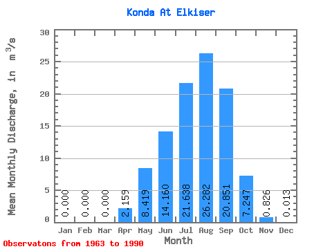
| Statistic | Jan | Feb | Mar | Apr | May | Jun | Jul | Aug | Sep | Oct | Nov | Dec | Annual |
|---|---|---|---|---|---|---|---|---|---|---|---|---|---|
| Mean | 0.00 | 0.00 | 0.00 | 2.16 | 8.42 | 14.16 | 21.64 | 26.28 | 20.85 | 7.25 | 0.83 | 0.01 | 8.47 |
| Standard Deviation | 0.00 | 0.00 | 0.00 | 3.06 | 12.07 | 26.40 | 27.49 | 35.16 | 34.28 | 8.60 | 1.00 | 0.02 | 8.81 |
| Min | 0.00 | 0.00 | 0.00 | 0.02 | 0.21 | 0.07 | 0.12 | 0.24 | 0.42 | 0.17 | 0.00 | 0.00 | 0.18 |
| Max | 0.00 | 0.00 | 0.00 | 13.40 | 54.10 | 117.00 | 114.00 | 110.00 | 166.00 | 28.60 | 4.30 | 0.10 | 34.06 |
| Coefficient of Variation | 1.42 | 1.43 | 1.86 | 1.27 | 1.34 | 1.64 | 1.19 | 1.21 | 1.81 | 1.04 |
 Return to R-Arctic Net Home Page