|
|
|||||||||||||||||
| Point ID: 6182 | Downloads | Plots | Site Data | Code: 3117 |
|
|
|||||||||||||||||
| Download | |
|---|---|
| Site Descriptor Information | Site Time Series Data |
| Link to all available data | |
| View: | Time Series | All |
| Units: | m3/s |
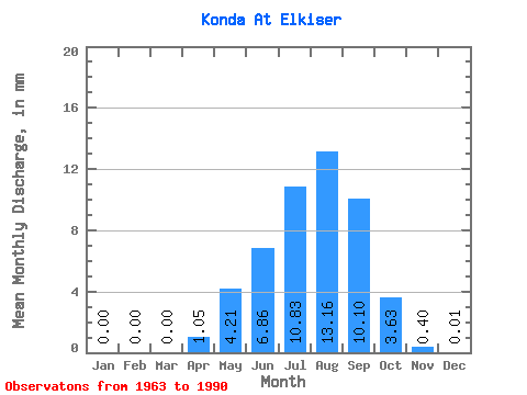
| Statistic | Jan | Feb | Mar | Apr | May | Jun | Jul | Aug | Sep | Oct | Nov | Dec | Annual |
|---|---|---|---|---|---|---|---|---|---|---|---|---|---|
| Mean | 0.00 | 0.00 | 0.00 | 1.05 | 4.21 | 6.86 | 10.83 | 13.16 | 10.10 | 3.63 | 0.40 | 0.01 | 49.94 |
| Standard Deviation | 0.00 | 0.00 | 0.00 | 1.48 | 6.04 | 12.79 | 13.76 | 17.60 | 16.61 | 4.30 | 0.48 | 0.01 | 51.95 |
| Min | 0.00 | 0.00 | 0.00 | 0.01 | 0.10 | 0.03 | 0.06 | 0.12 | 0.20 | 0.09 | 0.00 | 0.00 | 1.04 |
| Max | 0.00 | 0.00 | 0.00 | 6.49 | 27.08 | 56.69 | 57.06 | 55.06 | 80.42 | 14.32 | 2.08 | 0.05 | 200.90 |
| Coefficient of Variation | 1.42 | 1.43 | 1.86 | 1.27 | 1.34 | 1.64 | 1.19 | 1.21 | 1.81 | 1.04 |
 Return to R-Arctic Net Home Page