|
|
|||||||||||||||||
| Point ID: 6171 | Downloads | Plots | Site Data | Code: 3099 |
|
|
|||||||||||||||||
| Download | |
|---|---|
| Site Descriptor Information | Site Time Series Data |
| Link to all available data | |
| View: | Time Series | All |
| Units: | mm |
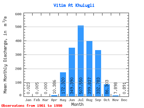
| Statistic | Jan | Feb | Mar | Apr | May | Jun | Jul | Aug | Sep | Oct | Nov | Dec | Annual |
|---|---|---|---|---|---|---|---|---|---|---|---|---|---|
| Mean | 0.02 | 0.01 | 0.00 | 10.39 | 172.32 | 349.39 | 507.55 | 399.84 | 332.78 | 86.30 | 7.90 | 0.89 | 151.31 |
| Standard Deviation | 0.09 | 0.03 | 0.00 | 13.94 | 138.30 | 360.70 | 461.34 | 368.79 | 306.36 | 56.96 | 6.29 | 1.06 | 86.46 |
| Min | 0.00 | 0.00 | 0.00 | 0.00 | 21.50 | 44.20 | 24.30 | 52.30 | 20.20 | 14.90 | 1.73 | 0.01 | 35.12 |
| Max | 0.50 | 0.16 | 0.00 | 52.20 | 581.00 | 1830.00 | 1660.00 | 1240.00 | 1460.00 | 233.00 | 25.20 | 4.54 | 305.27 |
| Coefficient of Variation | 4.00 | 5.48 | 1.34 | 0.80 | 1.03 | 0.91 | 0.92 | 0.92 | 0.66 | 0.80 | 1.19 | 0.57 |
 Return to R-Arctic Net Home Page