|
|
|||||||||||||||||
| Point ID: 6171 | Downloads | Plots | Site Data | Code: 3099 |
|
|
|||||||||||||||||
| Download | |
|---|---|
| Site Descriptor Information | Site Time Series Data |
| Link to all available data | |
| View: | Time Series | All |
| Units: | m3/s |
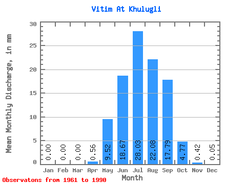
| Statistic | Jan | Feb | Mar | Apr | May | Jun | Jul | Aug | Sep | Oct | Nov | Dec | Annual |
|---|---|---|---|---|---|---|---|---|---|---|---|---|---|
| Mean | 0.00 | 0.00 | 0.00 | 0.56 | 9.52 | 18.67 | 28.02 | 22.08 | 17.79 | 4.76 | 0.42 | 0.05 | 98.46 |
| Standard Deviation | 0.01 | 0.00 | 0.00 | 0.74 | 7.64 | 19.28 | 25.47 | 20.36 | 16.37 | 3.15 | 0.34 | 0.06 | 56.26 |
| Min | 0.00 | 0.00 | 0.00 | 0.00 | 1.19 | 2.36 | 1.34 | 2.89 | 1.08 | 0.82 | 0.09 | 0.00 | 22.86 |
| Max | 0.03 | 0.01 | 0.00 | 2.79 | 32.08 | 97.80 | 91.66 | 68.47 | 78.03 | 12.87 | 1.35 | 0.25 | 198.65 |
| Coefficient of Variation | 4.00 | 5.48 | 1.34 | 0.80 | 1.03 | 0.91 | 0.92 | 0.92 | 0.66 | 0.80 | 1.19 | 0.57 |
 Return to R-Arctic Net Home Page