|
|
|||||||||||||||||
| Point ID: 6139 | Downloads | Plots | Site Data | Code: 3005 |
|
|
|||||||||||||||||
| Download | |
|---|---|
| Site Descriptor Information | Site Time Series Data |
| Link to all available data | |
| View: | Time Series | All |
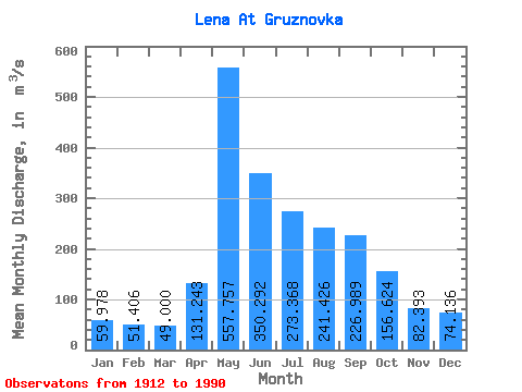
| Units: | mm |
| Statistic | Jan | Feb | Mar | Apr | May | Jun | Jul | Aug | Sep | Oct | Nov | Dec | Annual |
|---|---|---|---|---|---|---|---|---|---|---|---|---|---|
| Mean | 59.98 | 51.41 | 49.00 | 131.24 | 557.76 | 350.29 | 273.37 | 241.43 | 226.99 | 156.62 | 82.39 | 74.14 | 189.36 |
| Standard Deviation | 22.26 | 18.21 | 16.28 | 94.27 | 194.55 | 155.36 | 144.66 | 133.92 | 116.21 | 67.03 | 32.86 | 29.79 | 50.87 |
| Min | 22.80 | 21.90 | 22.60 | 37.30 | 139.00 | 126.00 | 84.90 | 76.00 | 71.20 | 44.60 | 29.60 | 24.40 | 88.83 |
| Max | 126.00 | 107.00 | 97.70 | 458.00 | 1130.00 | 898.00 | 831.00 | 803.00 | 729.00 | 385.00 | 173.00 | 156.00 | 362.19 |
| Coefficient of Variation | 0.37 | 0.35 | 0.33 | 0.72 | 0.35 | 0.44 | 0.53 | 0.56 | 0.51 | 0.43 | 0.40 | 0.40 | 0.27 |
 Return to R-Arctic Net Home Page