|
|
|||||||||||||||||
| Point ID: 6139 | Downloads | Plots | Site Data | Code: 3005 |
|
|
|||||||||||||||||
| Download | |
|---|---|
| Site Descriptor Information | Site Time Series Data |
| Link to all available data | |
| View: | Time Series | All |
| Units: | m3/s |
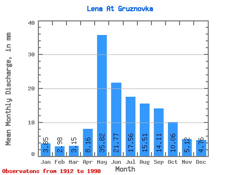
| Statistic | Jan | Feb | Mar | Apr | May | Jun | Jul | Aug | Sep | Oct | Nov | Dec | Annual |
|---|---|---|---|---|---|---|---|---|---|---|---|---|---|
| Mean | 3.85 | 3.01 | 3.15 | 8.16 | 35.82 | 21.77 | 17.56 | 15.51 | 14.11 | 10.06 | 5.12 | 4.76 | 143.32 |
| Standard Deviation | 1.43 | 1.07 | 1.04 | 5.86 | 12.49 | 9.66 | 9.29 | 8.60 | 7.22 | 4.30 | 2.04 | 1.91 | 38.50 |
| Min | 1.46 | 1.28 | 1.45 | 2.32 | 8.93 | 7.83 | 5.45 | 4.88 | 4.43 | 2.86 | 1.84 | 1.57 | 67.23 |
| Max | 8.09 | 6.26 | 6.27 | 28.47 | 72.57 | 55.82 | 53.37 | 51.57 | 45.31 | 24.73 | 10.75 | 10.02 | 274.12 |
| Coefficient of Variation | 0.37 | 0.35 | 0.33 | 0.72 | 0.35 | 0.44 | 0.53 | 0.56 | 0.51 | 0.43 | 0.40 | 0.40 | 0.27 |
 Return to R-Arctic Net Home Page