|
|
|||||||||||||||||
| Point ID: 6072 | Downloads | Plots | Site Data | Code: 7186 |
|
|
|||||||||||||||||
| Download | |
|---|---|
| Site Descriptor Information | Site Time Series Data |
| Link to all available data | |
| View: | Time Series | All |
| Units: | mm |
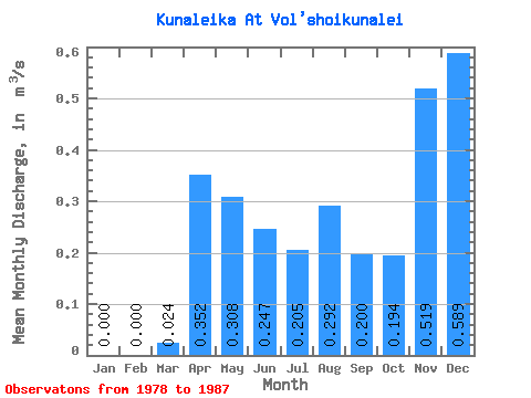
| Statistic | Jan | Feb | Mar | Apr | May | Jun | Jul | Aug | Sep | Oct | Nov | Dec | Annual |
|---|---|---|---|---|---|---|---|---|---|---|---|---|---|
| Mean | 0.00 | 0.00 | 0.02 | 0.35 | 0.31 | 0.25 | 0.20 | 0.29 | 0.20 | 0.19 | 0.52 | 0.59 | 0.47 |
| Standard Deviation | 0.00 | 0.00 | 0.04 | 0.14 | 0.19 | 0.28 | 0.13 | 0.38 | 0.16 | 0.14 | 1.25 | 1.16 | 0.44 |
| Min | 0.00 | 0.00 | 0.00 | 0.15 | 0.05 | 0.03 | 0.07 | 0.05 | 0.05 | 0.04 | 0.00 | 0.00 | 0.16 |
| Max | 0.00 | 0.00 | 0.10 | 0.53 | 0.65 | 0.86 | 0.44 | 1.28 | 0.60 | 0.48 | 3.83 | 2.33 | 0.78 |
| Coefficient of Variation | 1.60 | 0.40 | 0.63 | 1.15 | 0.65 | 1.30 | 0.81 | 0.74 | 2.40 | 1.97 | 0.93 |
 Return to R-Arctic Net Home Page