|
|
|||||||||||||||||
| Point ID: 6072 | Downloads | Plots | Site Data | Code: 7186 |
|
|
|||||||||||||||||
| Download | |
|---|---|
| Site Descriptor Information | Site Time Series Data |
| Link to all available data | |
| View: | Time Series | All |
| Units: | m3/s |
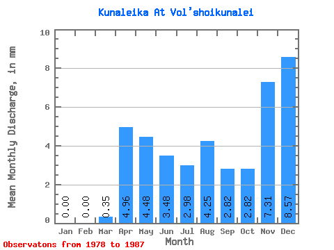
| Statistic | Jan | Feb | Mar | Apr | May | Jun | Jul | Aug | Sep | Oct | Nov | Dec | Annual |
|---|---|---|---|---|---|---|---|---|---|---|---|---|---|
| Mean | 0.00 | 0.00 | 0.35 | 4.96 | 4.48 | 3.48 | 2.98 | 4.26 | 2.82 | 2.83 | 7.31 | 8.57 | 80.69 |
| Standard Deviation | 0.00 | 0.00 | 0.56 | 1.98 | 2.80 | 4.01 | 1.95 | 5.53 | 2.29 | 2.10 | 17.54 | 16.89 | 75.31 |
| Min | 0.00 | 0.00 | 0.00 | 2.11 | 0.67 | 0.37 | 0.96 | 0.70 | 0.72 | 0.58 | 0.04 | 0.00 | 27.44 |
| Max | 0.00 | 0.00 | 1.46 | 7.47 | 9.46 | 12.12 | 6.40 | 18.63 | 8.45 | 6.99 | 53.95 | 33.91 | 133.94 |
| Coefficient of Variation | 1.60 | 0.40 | 0.63 | 1.15 | 0.65 | 1.30 | 0.81 | 0.74 | 2.40 | 1.97 | 0.93 |
 Return to R-Arctic Net Home Page